Is your Pompano Beach waterfront almost ready to hit the market, but you are not sure how to package the dock, depth, and tide details buyers will ask for first? You are not alone. Boaters shop with checklists, and those marine facts can make or break a showing. In this guide, you will learn exactly what to measure, document, and present for Pompano’s Intracoastal-connected canals, nearby inlets, bridges, and tides so qualified buyers can self-vet your property. Let’s dive in.
Start with Pompano’s waterways
If your dock connects to the Intracoastal Waterway, you are already speaking a boater’s language. Many Pompano Beach canals tie directly into the ICW, which is the main north–south route for recreational boats along the barrier island. Ocean access commonly happens through Hillsboro Inlet to the north or Port Everglades to the south. Which inlet you prefer affects time-to-ocean estimates and how boaters perceive the run.
Pompano’s local canals and basins vary in depth and width based on neighborhood design and dredging history. This is why measured depths with dates matter more than casual phrases like “deep water.” Think of your listing as a pilot chart for buyers: clear numbers and current conditions help them picture a safe, predictable approach.
Tides and why datum matters
Broward County’s tidal range is modest, generally about 1 to 2 feet, with local variations from wind, pressure, and seasonal king tides. Buyers do not shop by average water; they shop by the lowest predictable water. Always record and report depth at low tide and state the datum used. Mean Lower Low Water, or MLLW, is the preferred NOAA datum and gives buyers a clean comparison to charted channel depths.
Measure and prove your depths
Depth claims carry the most weight when you document how and when you took them. Use a depth sounder or hire a professional surveyor and note the date, time, and tide stage. Tie your readings to a recognized datum, ideally MLLW.
What to measure at your dock and approach
- Dock face at the centerline of the slip.
- Both edges of the slip where shoaling can occur.
- The approach path from your slip to the canal centerline.
- The canal entrance to the nearest maintained ICW channel.
Provide the actual numbers and context. For example: “Dock face 6.8 ft at MLLW, measured 06/10/2025, low tide.” That is far more useful to a buyer than “plenty of water.”
Tips for consistent reporting
- Take multiple readings on different days to confirm consistency.
- Save sounder screenshots or a simple depth sketch for your listing packet.
- If you plan to market specific draft limits, consider a professional survey to support those claims.
Bridges and air draft
Two details shape ocean access for many buyers: vertical clearance for tall vessels and horizontal clearance for wider powerboats.
Fixed vs draw bridges
- Fixed bridges have a single vertical clearance number that matters for a vessel’s air draft.
- Drawbridges open on set schedules and have published vertical clearance when closed and horizontal channel widths. Powerboat owners often focus on these widths and the alignment of fenders and piles.
Air draft is the height from the waterline to your vessel’s highest fixed point. Encourage buyers to compare their air draft to each fixed bridge between your dock and the ocean. In your marketing, include a simple note such as “Max air draft to ocean” or list whether a typical sailboat can reach the inlet under fixed bridges. Bridge clearances are published on NOAA nautical charts, and operating schedules are maintained by FDOT or the bridge operator.
Time-to-inlet and real-world conditions
Estimate cruising distance and time to your preferred inlet at a typical speed, and give a range rather than a single number. Currents, winds, and inlet sea state can stretch a run on a breezy day. Hillsboro Inlet and Port Everglades each have their own current patterns and surf conditions that vary by season. A short, honest range builds trust.
Channels, controlling depths, and dredging
Every maintained channel has a “controlling depth,” and it changes with shoaling and dredging cycles. The ICW is frequently maintained by the U.S. Army Corps of Engineers, while neighborhood canals can go longer between dredges.
- Identify the nearest maintained channel and note its controlling depth and last known dredge activity.
- If your canal is part of an HOA or canal association, gather any notes or plans related to shoaling and dredging.
- Avoid absolutes. Provide numbers, dates, and sources, and recommend that buyers verify against current charts and notices to mariners.
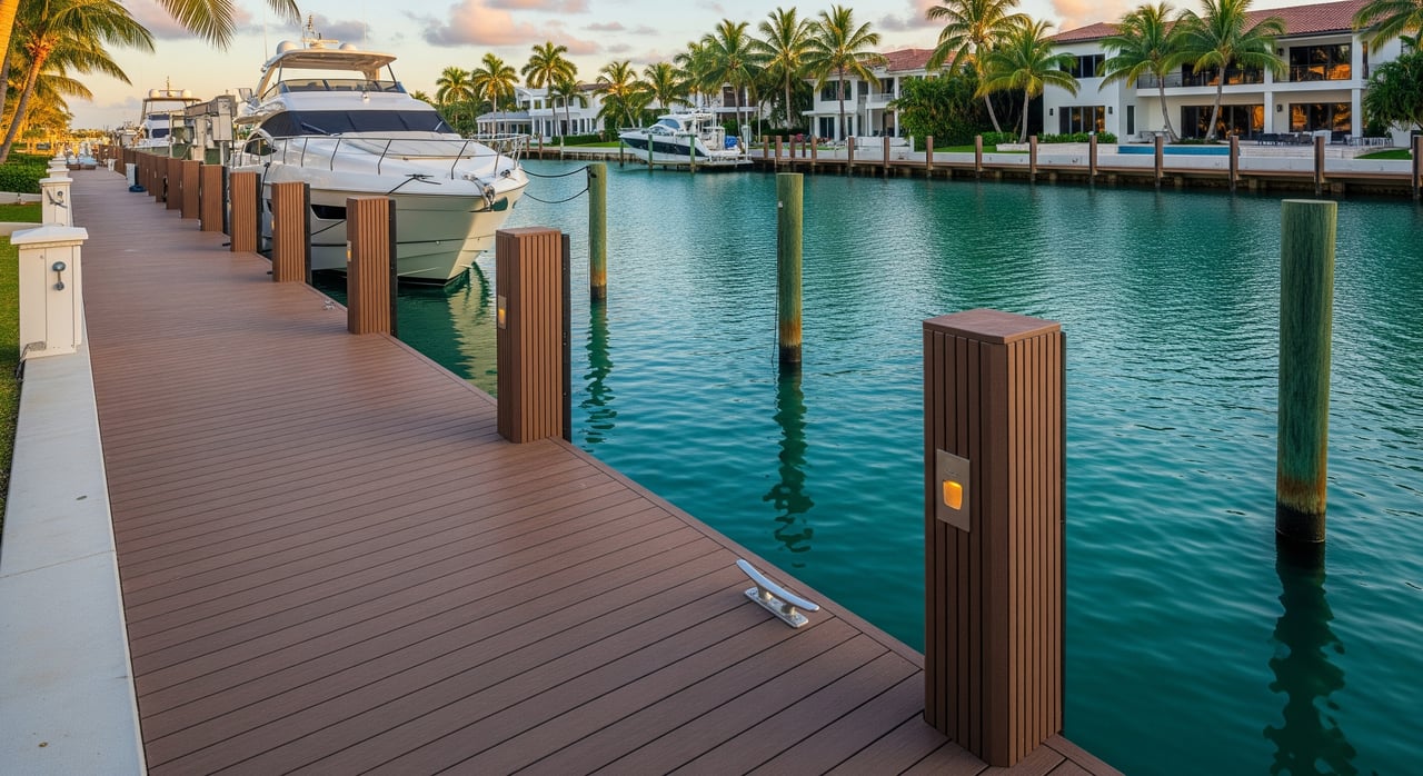
Document your dock, lift, and seawall
Create a complete, easy-to-scan profile so boaters can self-qualify quickly.
Dimensions buyers expect
- Overall dock length and width, plus usable length for handling.
- Slip length and beam, and any piling-to-piling measurements that limit beam.
- Usable Boat Length (UBL). State the maximum LOA and beam the slip accommodates, accounting for pilings, fenders, and safe overhang.
- Distances: from the seawall to the canal entrance and to the nearest maintained ICW channel.
Structural components and utilities
- Dock type: fixed or floating; materials and condition of pilings.
- Boatlift: type, brand, rated capacity, age, maintenance history, lift height, and hurricane tie-down provisions.
- Mooring gear: cleat locations and ratings, fendering and rub rails.
- Electrical: shore power availability (30A or 50A), pedestal location, connector type, GFCI protection.
- Water and lighting: hose bibs, deck lighting, pump-out access nearby, and proximity to fuel.
Seawall and bulkhead
- Age and material of the seawall or bulkhead, plus any recent inspections or repairs.
- Permits and engineering notes for replacement or reinforcement.
- Any elevation plates or recorded elevations that help buyers understand flood and surge context.
Permits, rules, and who to call
Pompano Beach sellers should assemble clear documentation before going live. This gives buyers confidence and reduces back-and-forth.
- City of Pompano Beach Building Division for local permits and inspections related to docks, lifts, and seawalls.
- Broward County environmental and permitting offices for county-level shoreline work and records.
- Florida Department of Environmental Protection for coastal construction or work below mean high water lines.
- U.S. Army Corps of Engineers for jurisdictional permits and notices to mariners.
- Florida Department of Transportation and the U.S. Coast Guard for bridge clearance data and operating schedules.
- South Florida Water Management District if water-management considerations apply to your area.
If your property is part of an HOA or canal association, include covenants or rules that impact dock size, boat types, lift installations, or maintenance obligations. Insurance carriers often ask about seawall condition and lift certification, so keep those records handy.
Photos and video that boaters want
Strong visuals help qualified buyers imagine arrival, mooring, and daily use.
- Aerial drone shot showing your dock, approach path, and proximity to the ICW.
- Walk-the-dock video that highlights cleats, pilings, shore power, and a safe lift demonstration.
- Depth-sounder screenshots or a short clip capturing readings with the date and time.
- Bridge and inlet transit clips under typical conditions so buyers can see clearances and water state.
Build a Marine Facts block
Create a simple box in your listing so boaters can scan the essentials.
- Max LOA and max beam accommodated.
- Dock depth at MLLW, with date and time measured.
- Max draft given channel approach limits, if relevant.
- Lift capacity and age.
- Distance and estimated time to the preferred inlet.
- Nearest maintained ICW channel and most relevant bridge clearances en route.
- Nearest fuel and pump-out availability.
- Whether live-aboard is permitted under local rules or HOA, if applicable.
Safety and showing prep
Before showings, make the dock easy to tour and safe to access.
- Clear tripping hazards and secure any loose planks or lines.
- Add temporary signage to limit dock access during busy open houses.
- Replace worn mooring lines and confirm cleats are tight and ready.
- Stage a downloadable or printed marine packet with depth readings, permits, inspection reports, and lift documents.
How to present time-to-inlet
Buyers appreciate realistic ranges over optimistic best cases. Measure the distance to Hillsboro Inlet and Port Everglades and note a typical cruising speed for your neighborhood. Share a short range such as “about X to Y minutes at typical cruising speed,” and mention that conditions vary with tide, currents, and sea state at the inlet. This shows you understand what matters to boaters without overpromising.
Final pre‑market checklist
Use this final run-through before you list.
- Quick facts summary: max LOA, max beam, dock depth at MLLW with date, max draft if relevant, lift capacity and age, distance and time to the preferred inlet, nearest maintained ICW channel, bridge air-draft note.
- Documents: recent depth survey or soundings with date and tide stage, dock and seawall inspection reports, lift manuals and maintenance records, permits for any dock, lift, seawall, or dredging work, HOA or canal association rules and any dredge history.
- Visuals: drone approach shot, dock walkthrough, depth-sounder screenshots, inlet and bridge transit clip.
- Safety and seasonal notes: hurricane tie-downs for lifts, high-water tie points, and a recommendation that buyers arrange a “boat check” with their captain or marine surveyor.
If you are comparing notes with nearby markets like Delray Beach, remember that inlet options, bridge operators, and certain permitting offices differ by county. Keep your facts Pompano-specific and invite buyers to verify details with current charts, notices to mariners, and a marine surveyor.
Ready to position your Pompano waterfront so serious boaters move fast and confidently? I can help you gather the right data, coordinate a professional dock and seawall review, and craft a Marine Facts package that elevates your listing and reduces unqualified inquiries. Schedule a Free Consultation with Michelle Yales to start your pre-market plan.
FAQs
How should I measure dock depth for a Pompano listing?
- Use a depth sounder or professional survey, record readings at low tide, and report depths to a recognized chart datum, preferably MLLW, with the date and time noted.
What does “controlling depth” mean near the ICW?
- It is the shallowest depth along a maintained channel segment and it changes with shoaling and dredging; verify the nearest channel’s controlling depth and last dredge activity before listing.
Which inlet should I reference for Pompano ocean access?
- Most sellers cite Hillsboro Inlet to the north and Port Everglades to the south; provide a realistic time range to your preferred inlet and note that currents and sea state can affect transit.
How do I calculate usable boat length for my private slip?
- Start with the slip’s true usable length, subtract clearance needed for pilings and fenders, consider safe overhang, and publish a clear max LOA and max beam so buyers can self-qualify.
Do I need permits to add or modify a boatlift in Pompano?
- Many lift installations and structural changes require permits; check with the City of Pompano Beach Building Division, Broward County, and when applicable the Florida DEP and USACE.
Can sailboats reach the ocean from my Pompano canal?
- It depends on air draft versus fixed bridge clearances along your route; list the bridges between your dock and the inlet, provide their clearances, and encourage buyers to verify with current charts.